

The U.S. Coast Guard documented Hurricane Ian’s damage in Fort Myers, Florida, from a flight over the area.
The aerial images show homes and buildings with roofs torn off, surrounded by debris, as well as beached boats and entire neighborhoods still inundated with floodwaters. Other aerial images surfacing from Florida show a damaged causeway to Sanibel Island and homes smoldering in Fort Myers Beach.
Fort Myers is one of the areas that was hit hardest by Ian. The storm made its first Florida landfall in Cayo Costa, a small barrier island about 23 miles from Fort Myers. The city was hit by more than 7 feet of storm surge and 150 mph winds.
(MORE: See the Scale of Destruction In Fort Myers)
More than 1,200 patients were being evacuated from hospitals in the Fort Myers region on Thursday as all of the health system’s facilities were without water, according to the Associated Press.
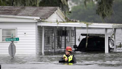
The Coast Guard and National Guard conducted rescues in the area Thursday morning, as people waited on roofs for aid, surrounded by floodwaters. Tens of thousands are still without power in and around Fort Myers.
(MORE: Hurricane Ian Live Updates)
Aerial photos are one way to assess Ian’s damage in a situation where the scope of destruction is just coming to light. Click through the slideshow above to see some images from the air.
MORE FROM WEATHER.COM: Photos Of Ian's Wrath In Florida
The Weather Company’s primary journalistic mission is to report on breaking weather news, the environment and the importance of science to our lives. This story does not necessarily represent the position of our parent company, IBM.


