

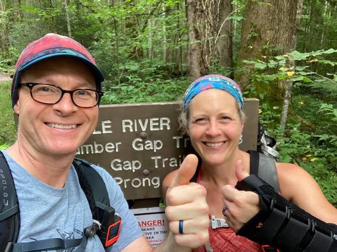


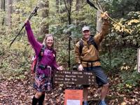

A hiker from Lake Junaluska has embarked on an extraordinary challenge and inspiring adventure to traverse all 900 miles of trail in the Great Smoky Mountains National Park in record time.
Nancy East and her hiking comrade in arms, Chris Ford from Tennessee, set out at midnight on Labor Day weekend, logging 39 miles on their first trail day. They’ve been consistently averaging between 25 and 30 miles a day their first two weeks.
The hiking duo — who go by the trail names “Seal Mom” and “Pacer” — are already part of an elite group known as the 900 Miler Club, those who’ve hiked all 900 miles of the Smokies’ trail system. Combined, they have hiked every mile of trail in the Smokies five times — East twice and Ford three times.
What makes their journey unique this time, however, is they are attemping the challenge end-to-end, hiking consecutive days until they’re finished — hopefully setting a 900-miler record in the process.
Their total mileage when done will well-exceed 900 miles, however, as it’s not possible to hike every trail mile in the Smokies without some degree of backtracking and doubling up.
They hope to raise $60,000 in donations for Friends of the Smokies to support the park’s newly launched Preventative Search and Rescue program. The initiative aims to educate hikers about trail safety to prevent rescues, and in the event a hiker becomes lost or injured, to increase their chances of being found.
The following interview with East took place before her journey began and detailed the daunting logistics of such an undertaking, as well as her inspiration behind the challenge.
The Mountaineer has partnered with Friends of the Smokies to publish excerpts of Dodd’s interiew.
FOTS: What was involved in designing the hiking plan for completing the 900 miles in a day-after-day and safe approach?
Our logistical plan was primarily created by Lane DeCost, my Search and Rescue teammate and a mutual friend. Lane loves a good analytical challenge, so he actually enjoyed the task of unwinding the Gordian knot of Smokies trails, in an effort to keep the routes as efficient as possible.
He effectively became our ‘trail boss’ in the process and has handled much of the behind-the-scenes logistical needs for us, in addition to creating the routes we will hike.
After Lane created the routes, Chris printed off enlarged maps of the Smokies trails, and we used things like Monopoly game pieces (the National Park version, coincidentally) to act as mock cars as we talked through each day’s hikes, how we’d position cars, and if we would need support from friends and family.
Our home base each night varies, and each night’s home base emerged after the hiking routes were finalized. Friends of the Smokies has been incredibly helpful in helping us find donated lodging in Gatlinburg, when it makes sense to stay on that side of the park. We are also utilizing various frontcountry and backcountry campsites in the park.
FOTS: What’s involved in determining your hiking routes?
The planned hiking routes are all considered higher mileage hikes for everyday hikers (over 20 miles), and we both plan to hike, not run, them. They vary in length according to the elevation gain and loss the team will cover along a specific route. Because they are all bound to be long days, the team intends to start early each day.
Most of the routes are one-way, meaning we start and end at different trailheads with minimal backtracking on trails and most string several trails or segments of trails together. Some trails, however, have unavoidable backtracking miles.
Our goal was to minimize the amount of mileage that needed to be walked twice, thereby creating a lower number of total miles hiked by the end of the challenge — and we feel as if we have dialed it in fairly efficiently.
FOTS: What is the role of your support team?
The primary role of the support team is to help shuttle cars for Chris and me, if needed. The Smokies’ network of trails often entails long driving distances between various trailheads.
It’s a time-saving advantage to have help shuttling cars or driving the team to a trailhead, eliminating the need to pick a car up after a long day on a hiking route.
Our support team will be a tremendous source of moral support, too. Chris’ wife, Jamie, along with my husband, Larry, have been huge sources of both strength and support for Chris and me throughout the entire training period.
FOTS: How did you and Chris decide to take on the Tour de Smokies?
I am a search and rescue team member on the North Carolina side of the park, and the search for Susan Clements was the primary catalyst for the Tour de Smokies.
(Clements is an Ohio woman who died of hypothermia while hiking in the Great Smoky Mountains in 2018.)
My team took part in this search, and it was a tragic reminder of how things can quickly go awry for a hiker who is not prepared for the ever-changing conditions in the Smokies.
I was motivated by this tragedy to do more educational outreach in the hiking community, to keep hikers ‘safe and found.’ When I discovered that Friends of the Smokies had a specific line item in their budget to raise funds for preventive search and rescue programs in the park, I came up with the idea to try to hike the park’s trails in record time, in an effort to raise money for this cause.
Chris also had ambitions of hiking the park’s trails in record time. So we began putting a plan in place to tackle the challenge together, while raising the funding for Friends of the Smokies.
FOTS: Your hiking fundraising goal is to raise $60,000 to hire seasonal rangers dedicated to teaching visitors about hiker preparedness and hiking safety topics. Why do you consider this to be such an important GSMNP mission?
From my search-and-rescue work, I know first hand how many hikers make decisions out of ignorance that quickly put them in life-threatening situations.
If hikers understand the inherent dangers of the backcountry and enter it with humility, they are much more likely to take what they need and learn the skills they need to stay safe.
Even the shortest and most popular trails can become life threatening to unprepared hikers. Susan Clements’ story is a profound and tragic testament to this fact.
If the funding from this effort proactively saves even one visitor’s life, it’s worth every penny and every step of pain we will walk to raise it.
FOTS: You have said it’s important to have a plan for the hike. Why is a hiking plan important and what does that planning include?
A hiking plan is important for a couple of reasons. First, it’s helpful in discerning whether or not the hike is safe, given its conditions, and if it’s within a hiker’s physical abilities.
Keep in mind that mileage doesn’t always align with exertion. For instance, Chimney Tops Trail is incredibly steep and challenging for its 2-mile distance. There are park trails that are twice as long that won’t leave your heart, lungs and knees screaming nearly as much.
The elevation gain and loss of the trail should also be considered, in conjunction with the mileage. Also, consider potential obstacles inherent to a specific trail, such as hazardous water crossings.
Food and water needs should also be determined. There’s nothing worse than drinking your last drop of water, only to discover you won’t come across another water source for several more miles!
I also encourage hikers to carry a little more food than they think they’ll need on a hike, just in case they’re out longer than they expect.
FOTS: Why is it important to let someone know your hiking plan?
It’s incredibly important to leave your hiking plan with a friend or family member and to let them know when you emerge from the woods safely.
The person who knows your plan should contact the park service if you don’t contact them by a predetermined time you agree upon before leaving. A hiking plan gives search and rescue teams a starting point if a hiker doesn’t return from a hike.
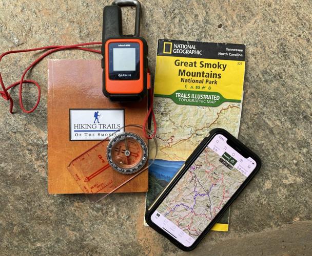
FOTS: Why do hikers need to carry a park map, a compass and even a satellite device? Aren’t the trail signs and a cellphone adequate?
Navigation intimidates most novice hikers, but it doesn’t need to be overly complicated. Navigational apps, such as Gaia GPS, provide a real-time snapshot of where hikers are on a trail, even without cell reception.
There’s absolutely nothing wrong with using a navigational app, and I even encourage every hiker to take the time to learn how to use one. However, it shouldn’t be the only thing hikers learn and carry.
All it takes is an unexpected dead battery or a phone dropping in a creek (I speak from experience!) to eliminate your only form of navigation.
A topographic map, paired with a compass, should also be in every hiker’s backpack.
And remember that a compass is just extra weight in your pack if you don’t know how to use it. Take the time to learn the basics of reading a topographical map and using a compass.
Always put your phone in airplane mode when you leave for a hike to preserve the battery life. And in winter, keep it as warm as possible. I like to activate a chemical hand warmer and keep it in the same pocket as my phone if it’s really cold.
Finally, one of the best navigational tools a hiker can use doesn’t weigh a thing. It’s a method called dead reckoning.
In my opinion, it’s just as important to learn dead reckoning as it is to carry a map and compass. In short, it amounts to keeping track of the time it takes you to hike between certain landmarks, such as trailheads. I use dead reckoning on every single hike I take, and it can actually turn into a fun game as you get better at it with experience.
FOTS: I’ve heard quite a few hikers say, ‘If I have any problem, I can use my cellphone to get help.’ As you’re experienced in search and rescue, what would you say to them?
As someone who has hiked all of the park’s trails twice, I can attest to the fact that cell reception is very limited in the park. It’s never ever a good idea to rely on it, especially if you have an emergency situation and need help.
One of the most harrowing experiences I’ve ever had as a hiker is when I came across two teenage boys in the Deep Creek trail network who had become separated from their group and were lost. It was winter, raining and the temperature was in the 40s, perfect conditions for hypothermia, especially since they weren’t dressed appropriately.
When I came across them, they were very tired, soaked and very cold. This was troublingenough, but what bothered me the most is when one of them told me they were considering heading off trail to try and get higher up on the mountain for cell reception.
If they hadn’t come across me when they did, I fear the worst may have unfolded. Personally, I wish every hiker could carry a personal locator beacon or satellite device with an SOS feature. Chris and I both carry the Garmin InReach Mini. It allows us to send a signal with our GPS coordinates to emergency services if we have an injury and can’t hike out or if we become lost.
But it also allows us to send personalized messages to convey why we need help. It can also be used to send messages to our spouses, if we’re running late getting off trail, want to tell them we’re safely in a backcountry camp for the night, etc.
FOTS: Hikers who have a map may think a shortcut they would devise could be faster or more adventurous than following the trail. Why isn’t that a good idea?
Unless someone is highly proficient with map and compass navigation, I would strongly discourage off-trail travel. If you veer from your planned route and get injured or lost, you instantly become the proverbial needle in a haystack to search-and-rescue teams. Also, the terrain of the Smokies is brutal and unforgiving in many places, so your risk of injury increases significantly off trail.
Julie Dodd is an educator, nature enthusiast, runner, hiker and photographer who volunteers as the chief blogger for the Friends of the Smokies. You can often find her hiking to Mt. LeConte — a trail she’s done 55 times in all — 56 if you count this summer’s virtual LeConte hike.


Post a comment as anonymous
Report
Watch this discussion.
(0) comments
Welcome to the discussion.
Log In
Keep it Clean. Please avoid obscene, vulgar, lewd, racist or sexually-oriented language.
PLEASE TURN OFF YOUR CAPS LOCK.
Don't Threaten. Threats of harming another person will not be tolerated.
Be Truthful. Don't knowingly lie about anyone or anything.
Be Nice. No racism, sexism or any sort of -ism that is degrading to another person.
Be Proactive. Use the 'Report' link on each comment to let us know of abusive posts.
Share with Us. We'd love to hear eyewitness accounts, the history behind an article.