Guest post by Ken Porteus and Laurie Reed, Steering Group members of the Thornton le Street History Group
The ‘Roads to the Past’ project has now been running for some five years after being set up by the Thornton le Street History Group with the support of the National Lottery Heritage Fund and the Lottery players. The project had a primary aim to investigate whether or not there was a roman road running through or close to the village of Thornton le Street (near Thirsk) but there was also a secondary aim to look at the archaeology, history and people in the surrounding area.
As part of the project a group has been working with Tithe Maps and Tithe Apportionments covering a number of parishes in the area local to Thornton le Street in order to create a pictorial representation of the information contained. This blog outlines the process that was used to do this. [Please note that this project is separate from the Tithe Map project currently in progress at the North Yorkshire County Record Office.]
Dictionary definition of a Tithe
One tenth of the annual produce of land or labour, formerly taken as a tax for the support of the Church and clergy.
Survey for the purposes of setting a Tithe
During the 1830’s and 1840’s a survey was taken by parish covering the whole of England and producing two forms of information:
- A Tithe map laying out a picture of the fields and plots of land
- A Tithe apportionment giving details about each field or plot of land
On the tithe map each field or plot of land was given a number within the parish and this provides a link between the map and the Tithe apportionment information.
The Tithe apportionment document provides the following information:
- Landowner
- Occupier
- Number referred to on the Tithe map
- Name and description of Lands and Premises
- State of Cultivation
- Quantities in Statute measure (area in Acres, Rods and Perches)
- Amount(s) of Tithe payable (pounds, shillings and pence)
- Remarks
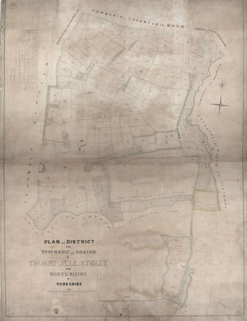
The following images show actual examples of the original Tithe Map and a page of the Tithe apportionment for Thornton le Street.

Bringing the Tithe map up to modern day standards
The quality and accuracy of the Tithe maps produced in the 1830’s and 1840’s vary and do not usually overlay exactly onto modern Ordnance Survey maps.
In order to produce a more accurate version, the old Tithe map has to be geolocated (that is accurately positioned) to a modern map. This can be a lengthy process and uses the positions of features which have not changed over time to tie points on both maps together and then careful stretching to fit everything as closely as possible.
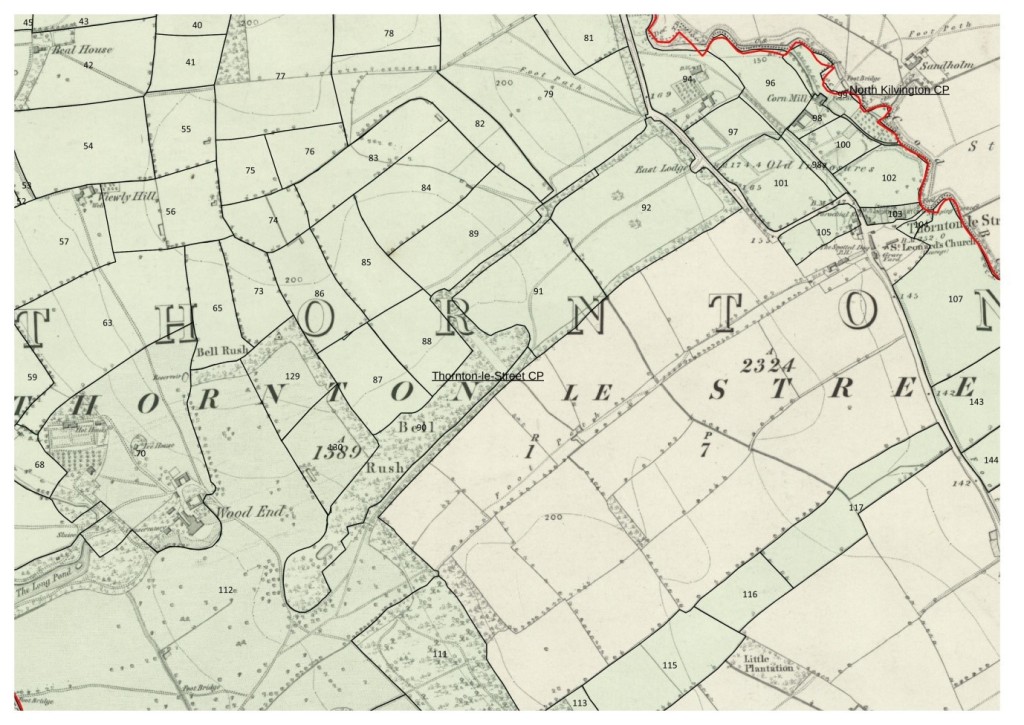
It can now be seen where the Tithe Map fields and land plots were exactly located with their associated numbers.
Creating an electronic copy of the Tithe Apportionments
The details of the Tithe Apportionment documents need to be held electronically and this is done by creating a spreadsheet and typing in the information in columns.
The Tithe Apportionments often name landowners or tenants once and it is important for the linking of information that each row of the spreadsheet is as complete as possible.

Bringing the map and apportionment data together
Now that we have the fields/properties numbered on both the accurate map and in the spreadsheet the two sets of information can be brought together and for this a GIS Software system is used, in this case a product called QGIS.
Each numbered field/property is redrawn as a shape polygon and given the original number from the Tithe Map within the QGIS system.
The spreadsheet is edited to remove any extra lines/headings/columns etc., i.e. back to the basic data and saved as a .csv (comma separated variable) file. This is loaded into the QGIS system and will link to the digitised map.
The Tithe Map number provides a link between each field/property in the QGIS system and the details about the field/property held within the spreadsheet.
Layers of information can then be created to present the information with text in a suitable format, shading of fields/property based upon selected data such as who owns the field/property, who tenants them, what the field/property names are and what type of cultivation was used on them at the time of the Tithe survey.
Each of these layers can then be displayed on the computer or printed out to present views of the information.
The following images show examples of the types of layers that can be produced.

Layer showing Ownership of land within the parishes of Thornton le Street, Thornton le Beans, Thornton le Moor and North Kilvington. Each colour represents a different owner and the original field/property numbers can be seen. 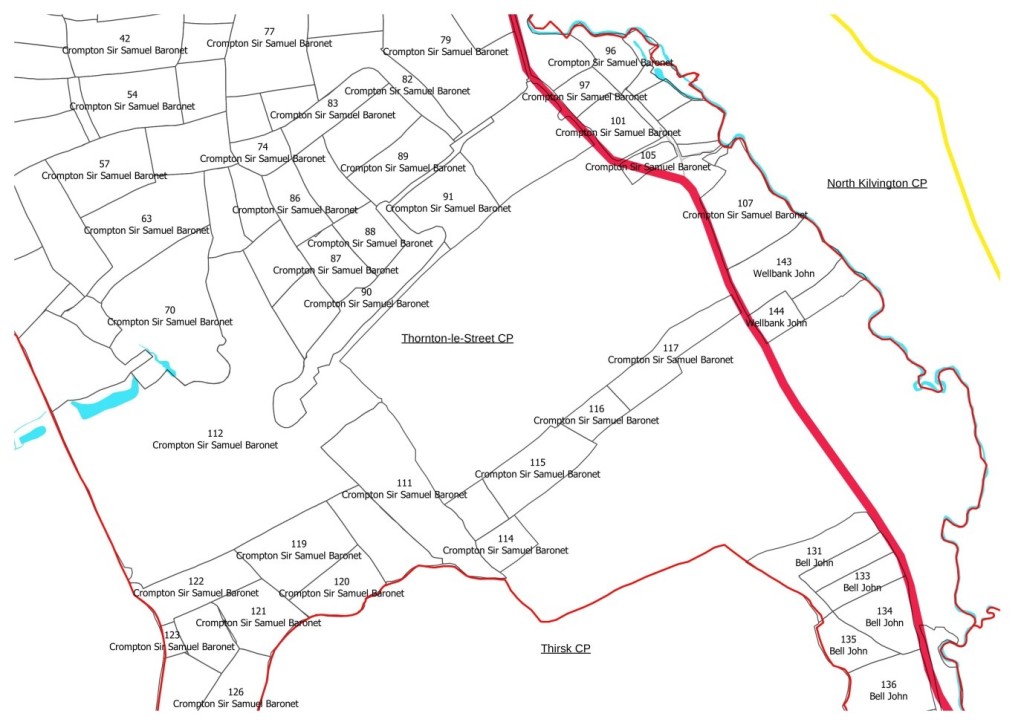
Layer showing the field/property ownership for Thornton le Street in more detail where the field/property numbers can be more clearly seen. 
Layer showing much more detail for parts of Thornton le Street and North Kilvington, each field/property now shows the field/property number, the name of the field/property and the tenant at the time of the Tithe survey. The shading indicates the different parishes. 
Map showing Thornton le Street and neighbouring parishes for which the tithe data has been digitised
As can be seen this fits with the old saying that ‘a picture paints a thousand words’ as views of information are presented visually and concisely.
A summary of what was required to produce these results
- A scanned copy of the Tithe Map
- A scanned copy of the 1st edition Ordnance Survey 6 inch map
- A modern georeferenced map
- A spreadsheet version of the Tithe apportionments
- GIS (Geographical Information System) computer software
Most importantly knowledge of how to use the above, particularly the computer software and a great deal of time.
Further information about the Group and the Roads to the Past project can be found at:
Website: www.thorntonlestreetbigdig.com
Twitter: https://twitter.com/TLSBigDig (@TLSBigDig)
The two project reports can be downloaded as pdf files:

‘Thornton-le-Street Through the Archives‘ a report resulting from hundreds of hours of volunteer research, translations & transcriptions.