For most sailors, buying search-and-rescue equipment is akin to purchasing earthquake insurance — something wise homeowners carry but hope to never, ever use. Take the well-documented example of Leopard, a 57-foot catamaran that was some 400 nautical miles north of the Dominican Republic, sailing south-southeast en route to St. Maarten on the evening of November 16, 2016. Capt. Charles Nethersole was aboard with crewmembers Carolyn Bailey and Bert Jno Lewis as Leopard negotiated 18-knot winds and lumpy seas with a double tuck in her mainsail. Realizing that they were overcanvased, Nethersole, a professional captain with 41 years of experience, and Lewis reefed the staysail while Bailey prepared dinner.
Nethersole and Lewis had just entered Leopard’s pilothouse, with Nethersole at the interior helm, when a meteorological juggernaut of wind and waves arrived via the starboard quarter.
“The boat got literally picked up,” said Nethersole, positing that they crossed tacks with a vortex-triggered pressure drop. “It was like being in an elevator. We went up, and then we just went over.”
The sea-smart crew quickly grabbed their ditch bag, immersion-survival suits and Leopard’s life raft, and escaped the saloon for the (relative) safety of the inverted wingdeck, where Nethersole activated the boat’s ACR GlobalFix Pro EPIRB. Several hours later, a U.S. Coast Guard C-130 arrived and directed the Mexico-bound bulk carrier Aloe to their rescue.
While you can bet your keel that abandoning ship was the last thing on the Leopard crew’s mind three minutes before encountering their crisis, their story highlights the four critical components to a successful search-and-rescue operation, namely the ability to alert, locate, track and rescue a stricken vessel or mariner. Given that Leopard’s emergency position-indicating radio beacon, or EPIRB, continuously reported its GPS location, along with its vessel-registered 406 MHz emergency satellite-communications signal, rescuing authorities were quickly alerted to the emergency and updated with the EPIRB’s position information. This let the Coast Guard pinpoint the catamaran and direct its rescue.
Yet while Nethersole and company enjoyed a textbook-perfect rescue, this would not have been possible without the International Cospas-Sarsat Programme, which began in 1979 as a collaborative effort by the United States, France and the former Soviet Union to provide a satellite monitoring and emergency-signal relay service that’s free of charge to all mariners.
Today, Cospas-Sarsat involves 43 nations that maintain an always-listening system of satellites and air-, land- and water-based assets. While contemporary search-and-rescue equipment and systems, including Cospas-Sarsat, have already saved at least 40,000 lives, the next-generation satellite-monitoring system promises better and faster service, along with the ability to support more sophisticated beacons, the first of which are already hitting chandlery shelves.
A Multilayered Network
Things get complicated when dozens of satellites, ground-monitoring stations and different rescuing authorities, such as the Coast Guard, are involved. However, Cospas-Sarsat’s schema involves a five-step process that begins when a satellite-mounted transponder detects a 406 MHz emergency signal from an EPIRB or an individually registered personal locator beacon, or PLB.
The transponder either passes the information directly to an earth-based receiver, known as a local user terminal, or it stores and forwards when a ground station, or LUT, comes into range. Once the LUT receives the signal, it’s sent to a mission control center that’s located in the country of the beacon’s registration. From there, the mission control center directs the message to a rescue coordination center, which conducts the physical rescue.
The speed with which an emergency signal reaches a rescue coordination center depends on where the emergency signal originated and what kind of satellite received the call. Cospas-Sarsat currently has two fully operational satellite constellations aloft, with a third under construction. Each system works in a different manner, but collectively, these different constellations provide redundant and complementary safety layers.
Cospas-Sarsat’s first-generation and still active Low-Altitude Earth Orbit Search and Rescue system is a constellation of five satellites. LEOSAR satellites use Doppler processing to pinpoint a beacon’s location, without a GPS position sent from the EPIRB or PLB. LEOSAR coverage is noncontinuous and requires multiple satellite passes, each taking roughly 100 minutes, to triangulate a beacon’s latitude and longitude. Also, because these satellites sometimes store information while waiting for contact with a ground station, a rescue operation can be further delayed.
Cospas-Sarsat’s second-generation Geostationary Orbit Search and Rescue system, known as GEOSAR, involves a constellation of six geostationary satellites that provide continuous coverage and the ability to quickly alert a ground station to an active 406 MHz signal. Unlike LEOSAR, GEOSAR satellites can’t use Doppler processing to self-calculate a beacon’s position, so contemporary EPIRBs and PLBs, including ACR’s GlobalFix Pro, which Leopard’s crew used, include a built-in global navigation satellite system (GNSS) receiver, allowing the beacon to determine its exact position information from GPS (United States), GLONASS (Russia) or Galileo (EU) satellites. The position fix is then sent by the rescue beacon to the satellite and relayed to the appropriate rescue agencies. While GNSS information dramatically reduces the amount of time it takes for rescuers to arrive on scene, not all EPIRBs are currently required to carry GNSS receivers. When buying a rescue beacon, it’s important to know if it includes this feature.
The third layer in Cospas-Sarsat’s ever-evolving network, the Medium-Altitude Earth Orbit Search and Rescue system, known as MEOSAR, won’t be fully operational until 2021 or 2022, but once complete, it will involve a constellation of 72 different satellites, plus upgraded terrestrial assets, including significantly advanced antennas.
MEOSAR incorporates the best of its forebears, namely LEOSAR’s Doppler processing and GEOSAR’s GPS-positioning capabilities. Once complete, MEOSAR will be able to quickly triangulate a beacon’s signal and nearly instantaneously share this information with an LUT. One caveat, however: MEOSAR will not offer coverage in the highest latitudes.
While Nethersole and company endured some worrisome hours before the C-130 arrived, in the future, those in peril will not have to wait to see if their signal was received and whether rescuers are on their way. Galileo satellites within MEOSAR’s constellation will include a return link signal (operational with properly equipped EPIRBs by 2018) that notifies a beacon user when their signal has been received.
This peace of mind can prevent life-and-death dominoes from toppling. Sean McCrystal, McMurdo’s marketing manager of search-and-rescue solutions, recalls the story of four Irish mariners whose vessel sank. They activated their EPIRB, but a crisis of confidence ensued; convinced that their signals hadn’t been received, three of them swam for shore and drowned. The fourth was rescued. “They made their decision because they didn’t think help was coming,” says McCrystal.
New Features Soon
In addition to being faster, MEOSAR’s advent, coupled with recently issued Federal Communications Commission regulations, allows EPIRB manufacturers to innovate in life-saving ways. For example, McMurdo’s recently released FastFind G8 AIS broadcasts four signals. Two are data feeds associated with satellites, 406 MHz and 121.5 MHz (a legacy frequency employed by rescuing authorities for final-mile homing using specialized equipment), and the other two incorporate a GPS location and automatic identification system (AIS) data, which alerts all local AIS-equipped traffic to the emergency signal so they can quickly render assistance.
This is a critical upgrade because previous EPIRBs only transmitted satellite-communication signals, meaning that while an official rescuing agency gets notified, nearby traffic is electronically blind to any nearby plights. By also broadcasting an AIS signal, the crews of AIS-enabled boats will see emergency alerts on their chart plotter or AIS display. And if their own EPIRB has accidentally activated, it will stave off false alarms. As of this writing, McMurdo is the only manufacturer to offer a multi-signal EPIRB, but other players likely will follow.
Interestingly, while manufacturers are adding AIS to their EPIRBs, MEOSAR will theoretically allow them to remove other frequencies. “Next-generation EPIRBs won’t need a GNSS-derived GPS location because of the sheer number of satellites, and also because ground stations are so much more accurate,” says McCrystal.
Still, while MEOSAR’s Doppler location-processing capabilities may remove the need for GNSS, the data broadcast is likely to be included because Cospas-Sarsat employs a multilayered approach.
“Technology is always getting better — for example, the additional level of satellites — but LEOSAR and GEOSAR are still fully operative and will continue to work,” says Nichole Kalil, ACR Electronics’ public affairs and media manager. “MEOSAR is the icing on the cake.” Because of this, EPIRBs will need GNSS receivers (at least) until older satellites are retired. In fact, the FCC is requiring that all new EPIRBs sold in the United States after January 1, 2019, be GNSS-equipped.
Besides a quicker rescue, sailors will benefit in other ways as manufacturers introduce new products. As with consumer electronics, feature lists are becoming richer while price tags are getting leaner, thus lowering an important barrier of entry. For example, a decade ago, a non-GNSS-equipped EPIRB sold for around $1,000. Today, $400 buys a contemporary GNSS-equipped beacon.
“You’re going to spend that or more on your Yeti cooler,” says Kalil. Additionally, EPIRB rental programs, such as the one that ACR and McMurdo have created with the BoatUS Foundation or that ACR has established with Sea Tow, help make safety gear readily attainable.
On a Personal Note
While EPIRBs are registered to vessels, PLBs are intended to be worn by individual crewmembers, which means you can carry one whenever you go out on the water, and on any boat.
PLBs that transmit 406 MHz satellite signals must be registered to individual sailors, just as an EPIRB gets registered to a particular boat. When activated, they connect with the Cospas-Sarsat network to alert rescuers ashore.
AIS-broadcasting personal beacons, which transmit on VHF radio frequencies, are programmed to send a signal to your own vessel and chart plotter or other AIS-equipped boats in the vicinity, but an alarm will not be picked up by any satellite network.
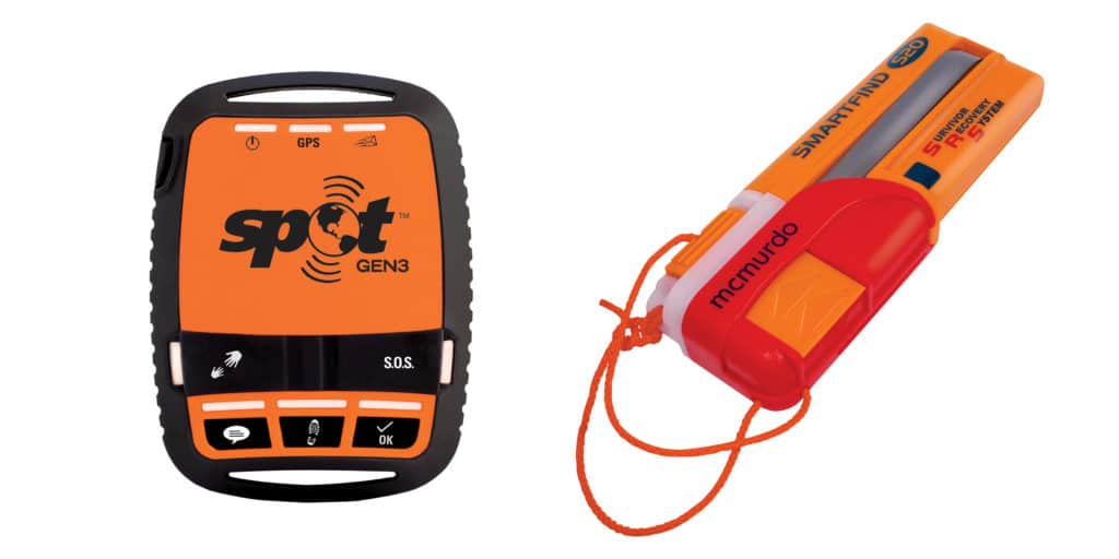
Examples of contemporary PLBs and AIS man-overboard devices include ACR’s ResQLink+ PLB and its new AISLink MOB, and McMurdo’s FastFind 220 and SmartFind 220.
In a perfect world, sailors could buy one device that would operate in both modes, but as of this writing, the FCC doesn’t allow a single personal device to broadcast both 406 MHz and AIS signals. Part of the issue, at least, is because of battery-life requirements and the limitations of just how big a power supply can be built into a pocket-size beacon. However, regulations remain the highest hurdle to jump before a single PLB-type device will be legally allowed to broadcast both 406 MHz and AIS signals.
As a result, some safety-conscious sailors carry multiple devices to ensure their emergency signals are heard by rescue authorities, local marine traffic and their own boat.
“It’s something the market wants,” says Kalil, adding that ACR is listening. Hopefully, the FCC will change its regulations, but until then, the best move is to stack the odds in your favor because the costs are relatively small and the return on investment is immense.
Manufacturers also build GPS communicators/messengers that can reliably be used in emergencies. Examples of this equipment include Garmin’s inReach and the Spot Satellite Messenger. Depending on the model, users can employ these devices to send pre-scripted messages to friends and family (e.g., “All good on our end.”), along with latitude and longitude information. Some models also let people on shore ping the unit to learn the user’s location information, and these devices also come with an SOS button that directly contacts the privately operated GEOS Rescue Coordination Center with the user’s position and personal information. It’s important to remember that GEOS is a private U.S.-based company, not an internationally funded, multinational government program like Cospas-Sarsat. However, the two organizations often contact the same rescue agencies in the event of an emergency.
Additionally, Garmin’s inReach devices can be paired with a user’s smartphone, taking advantage of its keyboard to type, send and receive short text messages via the unit’s Iridium satellite communication connection. Some inReach models include a built-in chart-plotter screen so the device itself can be used for navigation. Other units can share information via Bluetooth with a smartphone and tablet, providing those devices with location data. Users can also download weather reports. Unlike the other equipment discussed in this article, both the Spot and Garmin’s inReach require a monthly or yearly subscription service. However, these plans can sometimes be “winterized” during months of inactivity.
– – –
David Schmidt is CW’s electronics editor.