Around 900 BCE, a group of nomads from Siberia called Scythians began spreading across the central Asian steppe, their mounted archers sweeping across huge swaths of territory. Today the steppe from the Black Sea to northern China is dotted with thousands of their tombs—deep grave pits, covered with mounds of stone or soil. Centuries of looters have ransacked the burial mounds for the ornate gold art and jewelry, as well as the finely crafted weapons and horse gear buried with the Scythian dead. Satellite imagery sheds light on the extent of the destruction, and it may eventually help protect the ancient graves from modern looters.
University of Sydney archaeologist Gino Caspari and his colleagues searched for Scythian burial mounds, or kurgans, in high-resolution satellite images of a 110 square kilometer (68.4 square mile) area of the Xinjiang province in northwestern China. They mapped their findings and noted how many of the burial mounds looked like they’d been disturbed by looters. When looters dig up the contents of the grave pit, the center of the mound usually collapses. Observers who know what they’re looking for can spot that from above; imagine looking at a sheet of bubble wrap to see which ones have been popped. Although the satellite images weren’t as precise as a detailed ground survey, they offered a pretty accurate estimate of the general situation on the ground—and the news wasn’t good.
Nearly three-quarters of the burial mounds in northern Xinjiang have been looted. That came as a grim surprise for Caspari and his colleagues. “We assumed that, due to the remoteness and the heavy presence of security forces in the region, we would find a higher proportion of intact tombs,” he said in a statement.
An ancient problem
Looting is an old tradition on the steppe—as old as the oldest kurgans themselves. Some of those graves were plundered centuries ago, largely by enemy tribes seeking to stake a claim on the territory by desecrating the Scythians’ burial sites. But looting picked up steam in the 1700s with the Russian colonization of Siberia. At one time, looting was a seasonal industry on the steppe, with teams of a few hundred diggers working spring to autumn, pulling ancient treasures out of the ground and, in many cases, melting the precious metals down on site for easier transport to market.
Much of the damage to tombs in Xinjiang, however, may have taken place in the last 15 years, according to Caspari and his colleagues. The satellite images they used went back to 2003, and each year’s dataset showed a steady increase in the percentage of tombs that had been disturbed. It may not be a coincidence that the region has become much more accessible in that time—an airport opened in the nearby community of Kanasi in 2007. This made it easier for looters to reach the burial mounds and potentially opened up a new tourist trade in no-questions-asked antiquities.
“One might hypothesize that the increase in destruction of cultural heritage is tied to the opportunity for local people to establish a new market and sell looted archaeological items to tourists,” they wrote. But in order to make that connection, let alone do anything about it, it’s important to better understand more about the supply chain for illegal artifacts and the patterns of modern looters in the region. That’s something Caspari and his colleagues say satellite images may be able to help with.
“With satellite data time series, a constant and potentially automated monitoring could be implemented. Sites are not looted in one night, and once the destruction starts, there is usually enough time to go in and save or protect what is left,” Caspari told Ars Technica. “Traditionally, working with the local population who knows the area and employing them as guards has proven to be effective.” As a last resort, archaeologists can excavate the site quickly, to ensure that the burial is scientifically documented and that human remains and important artifacts aren’t lost or destroyed. That’s an expensive option, however, and archaeologists like Caspari say it’s better to preserve intact burial mounds than rush an excavation.
-
Caspari and his colleagues found this freshly-looted burial mound in Xinjiang.Caspari et al. 2018
-
It's hard to say when looters dug out the central pit of this burial mound.Caspari et al. 2018
-
This burial mound was also looted sometime in its past.Caspari et al. 2018
-
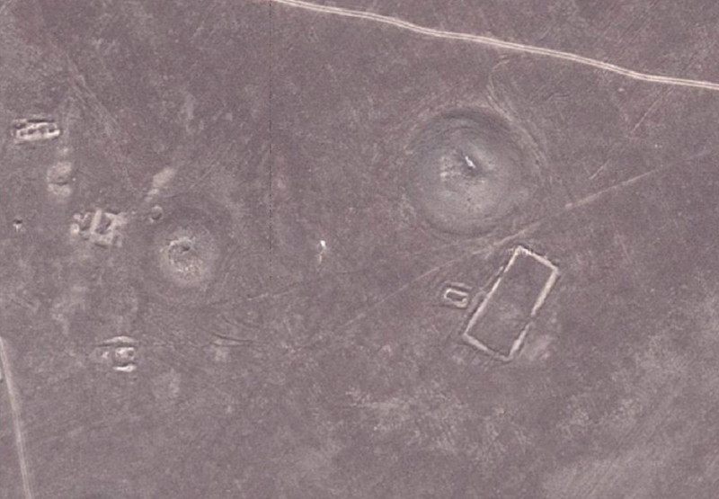
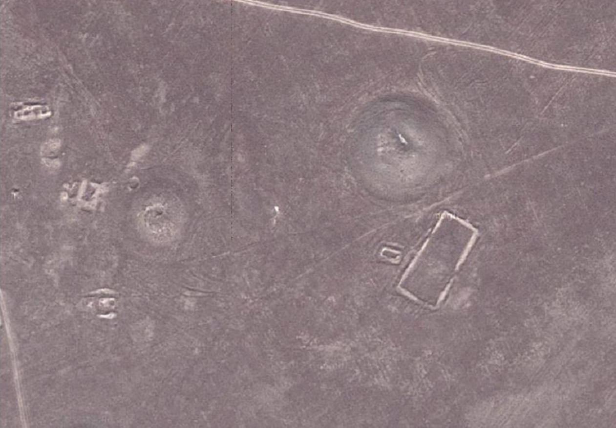
This Google Earth image shows two large Scythian burial mounds, each over 20 meters (65.6 feet) wide.Caspari et al. 2018
-
This Ikonos image shows two large Scythian burial mounds, each over 20 meters (65.6 feet) wide.Caspari et al. 2018
-
This Worldview-2 image shows two large Scythian burial mounds, each over 20 meters (65.6 feet) wide.Caspari et al. 2018
A modern solution?
“In most cases cultural heritage administrations have only a vague idea of what is out there. Establishing an inventory is a first step in knowing how and where to allocate the means to protect sites,” Caspari told Ars.
Caspari and his colleagues made a trip to Xinjiang to check how well the satellite survey captured what archaeologists could see on the ground. Due to the resolution of the satellite images, smaller burial mounds from about three to five meters (9.8 to 16.4 feet) in diameter didn’t show up or were too hard to distinguish from rock outcrops and other natural terrain. Others had been too badly degraded over the centuries to stand out in satellite photos. The source of the images also mattered. Ikonos images showed just over a third of the 188 burial mounds the ground survey found, while Worldview-2 showed about 60 percent, and Google Earth showed nearly two-thirds.
Although they didn’t reveal every burial mound in the area, Caspari and his colleagues say the images could be a useful tool for archaeological surveys, especially in hard-to-access areas like Xinjiang. It’s been very difficult in recent years for international teams to get permission from the Chinese government to do fieldwork there, mostly due to political tensions in the region.
“Any foreign activity is closely monitored and perceived as a potential threat. This currently makes real cooperation in the field impossible,” Caspari, who has led field surveys in the area since 2015, told Ars. “Research on the ground is greatly influenced by nation-state policies. Working with satellite data can bridge research gaps and provide insights into site distributions across national borders.”
Despite the problems on the ground, the satellite imagery has provided archaeologists with a general idea of how much looting damage had been done. Caspari and his colleagues estimated that between 87.5 percent of the burial mounds in the Google Earth images and 73.8 percent of those in the Ikonos images had been disturbed. The ground survey estimated 74.5 percent of burial mounds in the survey area had been disturbed by looters at some point, but erosion over time can hide evidence of earlier looting, so the real extent of the damage may be even greater. That’s a good enough estimate to provide governments with a useful tool for making decisions about protecting sites, according to the researchers.
Of course, there’s a long way to go from one satellite survey to real satellite monitoring of endangered ancient sites. “This is unfortunately unlikely in the near future and beyond my abilities as a researcher. But at least talking about it will give cultural heritage managers an idea of what can be done,” said Caspari.
In the meantime, Caspari and his colleagues are working on ways to expand the satellite survey using machine learning and open-source satellite data, he told Ars Technica.
Heritage Science, 2018. DOI: 10.1186/s4094-018-021-0;(About DOIs).
reader comments
28