Europe Launches 'Aeolus' Satellite on Mission to Map Earth's Winds
The European launch company Arianespace successfully launched a new weather satellite today (Aug. 22). Named Aeolus, the spacecraft is the first satellite designed to measure Earth's winds on a global scale.
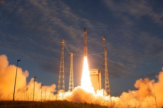
After a 24-hour weather delay caused (ironically) by strong winds, Aeolus lifted off on an Arianespace Vega rocket from the Guiana Space Center in Kourou, French Guiana, at 5:20 p.m. EDT (6:20 p.m. local time, 2120 GMT).
"All is fine on board," said Martin Kaspers, the product assurance manager for Aeolus, said during a live broadcast of today's launch. "We saw Vega take off like a shot ... rising like an arrow surprisingly fast," Kaspers said as he was overcome with emotion watching the long-awaited mission soar into space. [In Photos: Vega Rocket Launches 'Aeolus' Wind-Mapping Satellite]
The rocket's three solid boosters performed nominally as they took turns thrusting the satellite higher through the atmosphere and into space. One by one, the boosters ignited, separated and splashed down in the Atlantic Ocean. About an hour after liftoff, Aeolus separated from the rocket's fourth stage, the liquid-propelled Attitude and Vernier Upper Module (AVUM). "This is the moment where Aeolus will stand on its own and become an adult and go to work," Kaspers said.
Named after the Greek god best known as the "keeper of the winds" in Homer's epic poem "The Odyssey," Aeolus will spend the next three years mapping winds around the globe. (The satellite's full name is Atmospheric Dynamics Mission Aeolus.)

The European Space Agency (ESA) launched the Aeolus mission "to address the lack of global wind profiles in the Global Observing System," a network created by the World Meteorological Organization that is dedicated to studying weather and climate on a global scale, according to ESA's description of the mission. "Direct global profile measurements of wind fields are lacking, representing one of the largest deficiencies in the observing system and limiting improvements to numerical weather predictions and climate models," the description says.
Aeolus will measure winds around the globe from the surface of the Earth up into the stratosphere, to an altitude of 19 miles (30 kilometers). To put that into perspective, Earth's high-altitude winds, known as jet streams, typically flow west to east at altitudes of around 7 miles (11 km). But the highest winds on Earth are up in the mesosphere, which is just above the stratosphere and extends up to 53 miles (85 km) above the ground.
Get the Space.com Newsletter
Breaking space news, the latest updates on rocket launches, skywatching events and more!
By collecting data on the speed and direction of winds between the ground and the stratosphere and relaying that information to Earth in near real time, Aeolus will help improve the accuracy of weather forecasts around the world, ESA officials said. That data can also help scientists better understand climate change and predict how it will affect our planet in the long run.
Because it is hard to see, wind can be difficult to measure on a global scale. "The only way to achieve this is to probe the atmosphere from space using a highly sophisticated Doppler wind lidar," which uses laser pulses to make measurements, ESA officials said in a description of the Atmospheric Laser Doppler Instrument, or "Aladin," the wind-mapping instrument on Aeolus.
Aladin works by blasting small laser pulses and collecting the light that scatters off particles in the atmosphere using a 5-foot (1.5 meters) telescope dish. Its lasers will use ultraviolet light, which is not visible to the human eye. The satellite will be able to determine wind altitude by measuring the time it takes the light from Aladin's laser pulses to make the round-trip to and from a scattering particle.
"As the scattering particles are moving in the wind, the wavelength of the scattered light is shifted by a small amount as a function of speed," and measuring that change makes it possible to determine wind speed, ESA officials said. This change in wavelength is a phenomenon known as the Doppler effect.
While blasting lasers and taking measurements, Aeolus will remain in a near-polar, sun-synchronous orbit approximately 200 miles (320 kilometers) above Earth. This means that its path will seem to trace the line between night and day, and it will pass over the equator twice every day at the same times: 12 a.m. and 12 p.m. EDT (0400 and 1600 GMT).
ESA chose this orbit as "a compromise between acquiring the measurements and keeping fuel consumption to a minimum," ESA officials said in the mission's description. "A lower altitude increases the amount of fuel needed to maintain a steady orbit over the life of the mission," whereas the sun-synchronous orbit "provides maximum illumination from the sun and a stable thermal environment."
Aeolus will spend only 20 minutes per day on the nighttime side of Earth, when it will pass over the hemisphere that is experiencing winter (and is therefore tilted away from the sun).

Ground stations around the world will start receiving signals from Aeolus as soon as the satellite opens its solar arrays and orients itself so that Aladin is facing Earth. ESA scientists expect to hear a first signal from Aeolus today around 6:16 p.m. EDT (2216 GMT) via an ESA telescope at the New Norcia ground station in Australia.
Aeolus was originally scheduled to launch in 2007 after the mission was approved in 1999, but ongoing technical problems led to 11 years of delays. ESA contracted Airbus Defense and Space to build the Aeolus satellite, which has cost about $560 million (481 million Euros), according to IEEE Spectrum.
Email Hanneke Weitering at hweitering@space.com or follow her @hannekescience. Follow us @Spacedotcom, Facebook and Google+. Original article on Space.com.
Join our Space Forums to keep talking space on the latest missions, night sky and more! And if you have a news tip, correction or comment, let us know at: community@space.com.

Hanneke Weitering is a multimedia journalist in the Pacific Northwest reporting on the future of aviation at FutureFlight.aero and Aviation International News and was previously the Editor for Spaceflight and Astronomy news here at Space.com. As an editor with over 10 years of experience in science journalism she has previously written for Scholastic Classroom Magazines, MedPage Today and The Joint Institute for Computational Sciences at Oak Ridge National Laboratory. After studying physics at the University of Tennessee in her hometown of Knoxville, she earned her graduate degree in Science, Health and Environmental Reporting (SHERP) from New York University. Hanneke joined the Space.com team in 2016 as a staff writer and producer, covering topics including spaceflight and astronomy. She currently lives in Seattle, home of the Space Needle, with her cat and two snakes. In her spare time, Hanneke enjoys exploring the Rocky Mountains, basking in nature and looking for dark skies to gaze at the cosmos.
