

Just call it fake April.
An unusually wet weather pattern for early spring is shaping up across the region, as a series of soggy systems smack into the West Coast. By the time the first week of the month wraps up this weekend, Seattle could be closing in on 2 inches of rain—within shouting distance of the 2.71 inches that we average during the course of an entire April.
And, in case you haven’t looked out the window, the opening act is already well underway.
Light to moderate rain is currently rolling through the area as a warm front sweeps in from the Pacific, bringing up to half an inch of rain in many spots. The moisture looks to taper off later tonight, especially from about Seattle southward—before increasing in intensity again early tomorrow as a cold front roars ashore. An all-day rain, adding up to a half-inch or more, is expected Thursday. High temperatures will fall on the cool side, only maxing out in the lower 50s.
Intermission arrives just in time for Friday, with a relative break in the action as we return to the more traditional showers-and-sunbreaks April fare. If skies can clear enough, temperatures could even make a run at 60 degrees—something Seattle hasn’t experienced in over three weeks.
Act two then gets going in a hurry, with another round of rain barging into the Sound by early Saturday morning. This system looks to be the strongest of the entire week, with up to an inch of rain possible in Seattle by day’s end. While textbook for November, one-inch rainfalls become increasingly uncommon by April, with just 17 instances in the city’s entire climate record, stretching back to 1894. (By contrast, November has logged 129.) As luck would have it, though, Saturday (April 7) witnessed 1.54 inches of rain back in 2013 as repeated downpours plagued the airport—so a new daily rainfall record is likely out of reach.
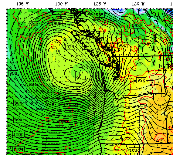
Outside of the rain, Saturday could also be quite windy by April standards, as a strong area of low pressure deepens off the West Coast. The latest forecast models show this storm gradually weakening as it plows into central Vancouver Island Saturday night, which would spare the region from damaging winds, but gusts to 45 mph are a good bet for most.
A reprieve in the stormy weather is anticipated for Sunday, with just leftover showers plaguing the area before the next system winds up offshore. By late Monday, damp conditions return to the region, continuing well into the middle of next week.
Some April, huh?


