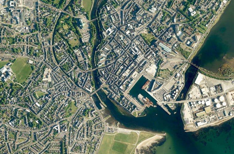
Bluesky Ireland has added around 30,000 square kilometres of geographic data to its online Mapshop. Now covering more than 70 percent of the Republic of Ireland, www.irelandmaps.ie
“We originally launched www.irelandmaps.ie
Bluesky originally announced plans to capture 70,000 square kilometres of aerial photography in 2014. Three successful flying seasons have seen the capture of significant portions of this target, with products including 25 cm resolution aerial photography, with complete or partial coverage over counties Carlow, Cavan, Cork, Galway, Kerry, Kildare, Kilkenny, Laois, Limerick, Longford, Louth, Meath, Offaly, Roscommon, Tipperary, Waterford, Westmeath, Wexford and Wicklow, and higher resolution, 12.5 cm, data for urban areas including Galway, Sligo, Limerick, New Ross, Enniscorthy, Gorey, Tralee and Wexford.
In addition to the aerial photography, Bluesky is offering colour infrared (CIR) data online, which provides a valuable tool for studies in vegetation extent and health, and other effects of human activity on the earth and its environment. Detailed height models, Digital Terrain Models (DTM) and Digital Surface Models (DSM), are also available at 2 meters and 25-centimetre resolutions respectively.
In another first for Ireland, Bluesky has added LiDAR data for Dublin to the Mapshop. Captured using aircraft-mounted lasers, LiDAR’s high level of accuracy and ability to penetrate vegetation offers the professional user a market leading spatial data source for a wide range of disciplines. New functionality on www.irelandmaps.ie also allows visitors to request quotes for bespoke projects including LiDAR data capture and the production of 3D Building Models.
More about Irish Tech News
Irish Tech News are Ireland’s No. 1 Online Tech Publication and often Ireland’s No.1 Tech Podcast too.
You can find hundreds of fantastic previous episodes and subscribe using whatever platform you like via our Anchor.fm page here: https://anchor.fm/irish-tech-news
If you’d like to be featured in an upcoming Podcast email us at [email protected] now to discuss.
Irish Tech News have a range of services available to help promote your business. Why not drop us a line at [email protected] now to find out more about how we can help you reach our audience.
You can also find and follow us on Twitter, LinkedIn, Facebook, Instagram, TikTok and Snapchat.