Scotland is famous for its scenic wild places and uplifting sense of remoteness. With the exception of the recent bylaws banning wild camping in certain areas of Loch Lomond and the Trossachs (check before you go), it is still completely legal to camp on most of Scotland’s unenclosed land.
The progressive Land Reform Act was passed in 2003, and the Scottish Outdoor Access Code was introduced in 2005, which lays out campers’ rights and responsibilities. Avoid camping in enclosed fields of crops or with farm animals, or too close to roads or buildings. Always take away your litter and remove any trace of a tent pitch or campfire.
For the adventurous, and those willing to tolerate some unpredictable weather, the rewards are plenty.
1. Sandwood Bay, Sutherland
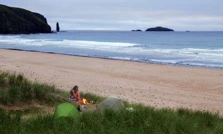
Pitch your tent amid the high rolling sand dunes at one of Britain’s most famous wild beaches. Reached only by a four-mile walk, this remarkable stretch of pink-hued sand, in northwest Sutherland, is bounded by cliffs and the Am Buachaille sea stack. The beach is popular with surfers and owned by the John Muir Trust. There’s some of the best-preserved machair wildflower grassland in mainland Scotland here, with more than 200 species of plant growing behind the dunes.
Park at the John Muir Trust car park in Blairmore (IV27 4RT). From the gate opposite, follow the well-marked track across moorland, turning left at the end of the second loch, towards the bay. Walking time from vehicle: 1½ hrs. Map ref: 58.5384, -5.0650.
2. Loch Beinn a’ Mheadhoin, Glen Affric
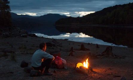
Hemmed by rugged mountains and ancient Scots pine, glassy Beinn a’ Mheadhoin is a peaceful freshwater loch nestled to the east of Scotland’s loveliest glen, the exceptionally picturesque Glen Affric. Numerous little islands and promontories make for fun adventure swimming, and the many small beaches are perfect for camping. The old tree stumps make hobbit-like seats for sitting around the campfire. To really get away from it all, canoe over to one of the islets and camp there.
From Cannich on the A381 take the road signposted Glen Affric past IV4 7NB. At about 8½ miles, roughly a quarter of the way up the loch, there is a large layby. Head down the bank towards the island linked to the shore by a sandy beach. Walking time from vehicle: 5 mins. Map ref: 57.2832, -4.9280.
3. Kilmory Bay, Isle of Rùm
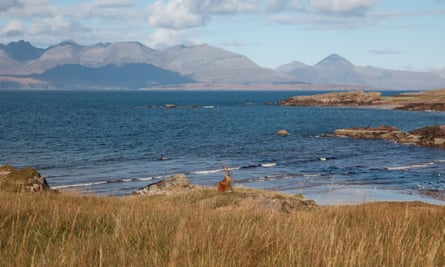
This magnificent bay on the wild northern coast of Rùm has a sandy beach looking straight out over the immense skyline of the Cuillins on Skye. Kilmory is the heart of the Red Deer Project, one of the longest and most complete studies of a wild animal population in the world. Look out for deer wandering the beach, and in late September and early October for rutting stags challenging each other.
From Kinloch Castle head north, then turn left along the Kinloch river into Kinloch Glen. Continue past waterfalls, and after another 1½ miles take the right fork. Follow the track, turning north another 2½ miles, before heading down to the beach. Walking time from vehicle: 2–2½ hrs. Map ref: 57.0499, -6.3545.
4. The Lost Valley, Glencoe
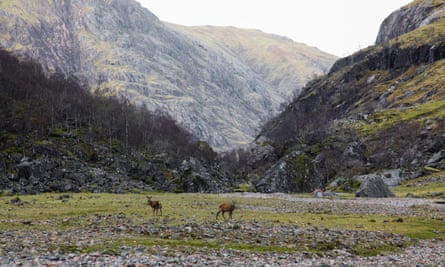
The otherworldly hanging valley of Coire Gabhail is hidden away from famous Glencoe behind a number of towering peaks. The secret glen has a dark past: it was here that many members of Clan MacDonald took refuge in the immediate aftermath of the Glencoe massacre in 1692. Guarded on all sides by mountains, it is the perfect place to camp, with a flat high meadow, meandering stream and giant boulders to shelter behind.
Park in one of the National Trust car parks on the A82 in Glencoe, 3½ and 5 miles E from PH49 4HX. The Lost Valley is the left of two valleys between the Three Sisters, the prong-like ridges jutting out into the glen. A decent path crosses the river Coe and winds up in the Lost Valley itself. Walking time from vehicle: 60 mins. Map ref: 56.6549, -4.9940.
5. Glen Nevis, Lochaber
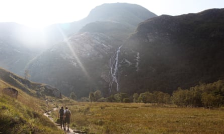
Combining breathtaking scenery with easy access, this picturesque glen in the heart of the Highlands is hard to beat. The steep-sided gorge is enveloped by the tallest mountains in Britain and opens up to reveal a hanging valley with alpine meadows. Here, the dramatic 120m-high Steall Falls pour into the scene, joining a beautiful river with plunge pools, and a famous wire bridge.
From Fort William take the road that winds up the glen (PH33 6SY) to the Upper Falls car park at the end. An obvious path leads up into the higher reaches of Glen Nevis, following the river. Walking time from vehicle: 20 mins. Map ref: 56.7723, -4.9814.
6. Vatersay, Outer Hebrides
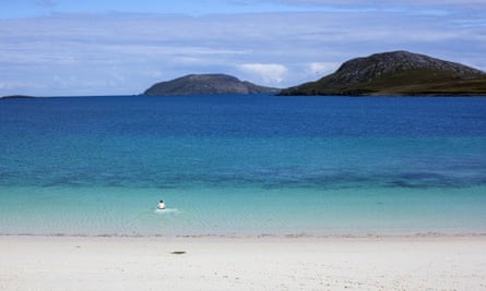
Idyllic Vatersay is the perfect place for those seeking island isolation. The southernmost inhabited island in the Outer Hebrides boasts a series of stunning beaches, surrounded by machair grasses that are ablaze with colourful wildflowers in spring and summer. Peaceful Vatersay Bay in the east has bright white sands lapped by clear turquoise water, great for swimming on a calm day. High sand dunes backing the bay also provide shelter for camping and picnics on this windswept island.
Cross the causeway at the south of Barra onto the island and follow the minor road south for approximately 3 miles. There is informal parking on the grass to the left, opposite a passing place and a signed path to a shipwreck monument. Walking time from vehicle: 5 mins. Map ref: 56.9236, -7.5353.
7. Glen Sannox, Isle of Arran
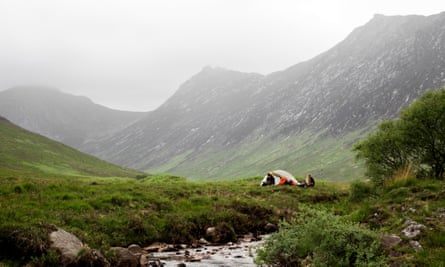
If Arran is “Scotland in miniature”, you can sample it all in Glen Sannox. This quintessentially Scottish glen curves up from the sandy bay at Sannox village and into the heart of the rugged Goat Fell mountain range. Running down the glen is the pretty Sannox Burn, edged by heather and bracken. At its northern end you can explore a number of pools and waterfalls which tumble through the forest.
From the car park in Sannox (near KA27 8JD) head west on well-signposted paths, then follow the burn up the glen. Walking time from vehicle: 1-2 hrs. Map ref: 55.6603, -5.1651.
8. Glenfeshie, Cairngorms
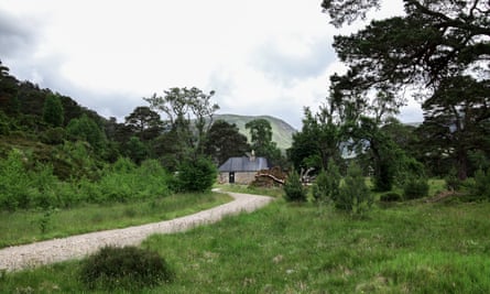
Home to one of the most successful “rewilding” projects in the country, the careful deer management at Glenfeshie has led to a host of young trees and a hugely increased variety of wildlife. There are foot and bike trails leading to Scots pinewoods, with tumbling waterfalls and mountain views. If you fancy upgrading for the night, seek out Ruigh Aiteachain, an MBA bothy deep in the glen where Sir Edwin Landseer studied the red deer for his famous painting, Monarch of the Glen. You might have it all to yourself.
From the B970 at Feshiebridge take the road signed Auchlean to a car park on the left after 4 miles. Walk ½ mile along the tarmac road ending at Achlean farm, pick up the main path through a gate and over a stream, and walk into the glen. Walking time from vehicle: 1–3 hrs. Map ref: 57.0353, -3.8963.
9. Loch Assynt, Sutherland
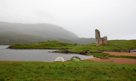
Set up camp on one of the grassy promontories overlooking enchanting ruins at the east end of Loch Assynt. Built by the MacLeods, Ardvreck castle dates back to the 16th century and local legend has it that the loch itself is home to the elusive “Mermaid of Assynt”, the MacLeods’ lost daughter Eimhir. It is said that in exchange for help building the castle the MacLeods pledged Eimhir to the Clootie (devil), and so in hiding from him she dived into the loch and began living underwater.
On the A837 north from Inchnadamph (IV27 4HN) park at a car park after 1½ miles, on the east shore of Loch Assynt. Walking time from vehicle: 10 mins. Map ref: 58.1664, -4.9944.
10. Quiraing, Isle of Skye

Watch the sunrise from your tent atop one of the many spectacular plateaux that make up this magnificent landscape. The Quiraing was formed by an ancient landslip that is still moving, and includes a jagged 37m-high pinnacle known as The Needle, a flat expanse of short grass called The Table, and a pyramidal rocky peak that resembles a medieval keep, and is known as The Prison.
Parking at summit of minor road between Uig and Staffin at 57.6281, -6.2909. Walking time from vehicle: 2 mins. Map ref: 57.6395, -6.2705.
Wild Guide Scotland: Hidden Places, Great Adventures & the Good Life by Kimberley Grant, Richard Gaston and David Cooper is published by Wild Things Publishing at £16.99. Readers can receive a 20% discount and free P&P with coupon code ‘GuardianScotland’ at wildthingspublishing.com
Comments (…)
Sign in or create your Guardian account to join the discussion