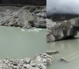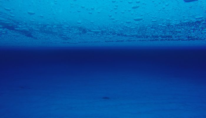
Who would have guessed that such a beautiful picture could get you interviewed for the national news?! Certainly not me! And yet, the photo of this englacial lake (a lake trapped within the ice in Antarctica), or rather science behind it, managed to capture the media attention and brought me, one of the happy co-author of this study, on the Belgian television… But what do we see on the picture and why is that interesting?
Where was the picture taken?
The Image of this Week shows a 4m-deep meltwater lake trapped 4 m under the surface of the Roi Baudouin Ice Shelf (a coastal area in East Antarctica). To capture this shot, a team of scientists led by Stef Lhermitte (TU Delft) and Jan Lenaerts (Utrecht University) went to the Roi Baudouin ice shelf, drilled a hole and lowered a camera down (see video 1).
Video 1 : Camera lowered into borehole to show an englacial lake 4m below the surface. [Credit: S. Lhermitte]
How was the lake formed?
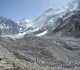
In this region of East Antarctica, the katabatic winds are very persistent and come down from the centre of the ice sheet towards the coast, that is the floating ice shelf (see animation below). The effect of the winds are two-fold:
- They warm the surface because the temperature of the air mass increases during its descent and the katabatic winds mix the very cold layer of air right above the surface with warmer layers that lie above.
- They sweep the very bright snow away, revealing darker snow/ice, which absorb more solar radiation
The combination leads to more melting of the ice/snow in the grounding zone — the boundary between the ice sheet and ice shelf — , which further darkens the surface and therefore increases the amount of solar radiation absorbed, leading to more melting, etc. (This vicious circle is very similar to the ice-albedo feedback presented in this previous post).
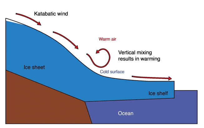
Animation showing the processes causing the warm micro-climate on the ice shelf. [Credit: S. Lhermitte]
All the melted ice flows downstream and collects in depressions to form (sub)surface lakes. Those lakes are moving towards the ocean with the surrounding ice and are progressively buried by snowfalls to become englacial lakes. Alternatively, the meltwater can also form surface streams that drain in moulins (see video 2).
Video 2 : Meltwater streams and moulins that drain the water on the Roi Baudouin ice shelf. [Credit: S. Lhermitte]
Why does it matter ?
So far we’ve seen pretty images but you might wonder what could possibly justify an appearance in the national news… Unlike in Greenland, ice loss by surface melting has often been considered negligible in Antarctica. Meltwater can however threaten the structural integrity of ice shelves, which act as a plug of the grounded ice from upstream. Surface melting and ponding was indeed one of the triggers of the dramatic ice shelves collapses in the past decades, in the Antarctic Peninsula . For instance, the many surfaces lakes on the surface of the Larsen Ice shelf in January 2002, fractured and weakened the ice shelf until it finally broke up (see video 3), releasing more grounded ice to the ocean than it used to do.
Of course surface ponding is not the only precondition for an ice shelf to collapse : ice shelves in the Peninsula had progressively thinned and weakened for decades, prior their disintegration. Our study suggests however that surface processes in East Antarctica are more important than previously thought, which means that this part of the continent is probably more vulnerable to climate change than previously assumed. In the future, warmer climates will intensify melt, increasing the risk to destabilise the East Antarctic ice sheet.
Video 3 : MODIS images show Larsen-B collapse between January 31 and April 13, 2002. [Credit:NASA/Goddard Space Flight Center ]
Reference/Further reading
- Meltwater on an East Antarctic ice shelf | Web story on the study
- Glaciology: Vulnerable Antarctic ice shelves | Nature Climate Change News and Views on the study
- Lenaerts, J. T. M., S. Lhermitte, R. Drews, S. R. M. Ligtenberg, S. Berger, V. Helm, C. J. P. P. Smeets, et al. 2017. “Meltwater Produced by Wind–albedo Interaction Stored in an East Antarctic Ice Shelf.” Nature Climate Change 7 (1). Nature Research: 58–62. doi:10.1038/nclimate3180.
Edited by Nanna Karlsson