
Update, 3:45 p.m., Wednesday, Aug. 23, 2017
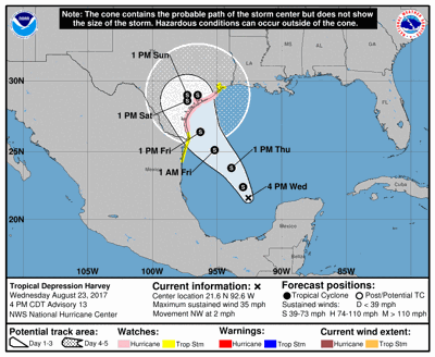
Tropical Depression Harvey hasn't strengthened much Wednesday and is crawling northwest at 2 miles per hour, the National Weather Service said in its 4 p.m. advisory. But quick intensification and and accelerated movement are expected in the next day or so.
Harvey remains a depression with max winds at 35 mph. But the system is expected to move over warm water and into an environment with low wind shear, both of which will be conducive to strengthening. It's possible Harvey will be a hurricane before it makes landfall along the Texas coast, the NHC said.
Key Messages for Tropical Depression #Harvey Advisory 13 pic.twitter.com/EYophVt30E
— NHC Atlantic Ops (@NHC_Atlantic) August 23, 2017
Update, 12:39 p.m., Wednesday, Aug. 23, 2017
Tropical Depression Harvey isn't moving much but is expected to resume its northwest track soon, the National Hurricane Center said in its 1 p.m. update.
A track toward the northwest or north-northwest is expected for the next 48 hours. On the forecast track, Harvey should be approaching the Texas coast late Friday, according to the NHC.
Maximum sustained winds are around 35 mph.
Update, 9:58 a.m., Wednesday, Aug. 23, 2017
After Harvey reformed into a tropical depression Wednesday morning, it was expected to be upgraded to a tropical storm Wednesday before heading toward Texas, according to a 10 a.m. update from the National Hurricane Center.
The current track indicated the storm could make landfall between Friday and Saturday morning. Sustained winds have been tracked at up to 35 mph. Several days of heavy rainfall are expected across portions of eastern Texas, Louisiana and the lower Mississippi Valley next week, the NHC said.
Here is the latest on Tropical Depression #Harvey. A lot of uncertainty & main concern right now is threat for heavy rain. #LAwx #MSwx pic.twitter.com/cGgLTfyeoy
— NWS New Orleans (@NWSNewOrleans) August 23, 2017
Storm surge, tropical storm and hurricane watches have been issued for portions of Texas.
Up to 10 inches of rain is possible in the New Orleans area over the coming week, according to the National Weather Service.
Another update will be provided about 1 p.m.
Can't see the video below? Click here.
ORIGINAL STORY
Tropical Depression Harvey reformed in the Gulf of Mexico on Wednesday morning, according to the National Hurricane Center. The system could bring a prolonged period of heavy rainfall and possible flooding to south Louisiana later this week.
Reports indicated a recon plane registered sustained winds of up to 35 mph. The system could form into a tropical storm as early as today, or possibly on Thursday, according to reports from WWL-TV.
The NHC said it will be re-initiating advisories for the storm system beginning at 10 a.m. Harvey is currently centered over the southwestern Gulf of Mexico.
The system could produce storm surge and tropical storm or hurricane force winds along portions of the Texas coast later this week, the Hurricane Center said earlier Wednesday. Tropical storm or hurricane watches could be required for portions of the Texas and Louisiana coasts.
.@NWSWPC is forecasting significant rainfall over parts of Texas and Louisiana through early Monday with #Harvey: https://t.co/G8R4gIFTDd pic.twitter.com/LXxCRWoHwg
— NHC Atlantic Ops (@NHC_Atlantic) August 23, 2017
Gov. John Bel Edwards on Tuesday said that his administration was monitoring the storm, and the Governor's Office of Homeland Security and Emergency Preparation would establish a crisis team Wednesday.

New Orleans, in consultation with state and federal officials, is developing a plan to evacu…

Louisiana leaders met with the newly minted head of the Federal Emergency Management Agency …


