Publications
 Partners


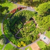
San Francisco - Google's free online mapping service is bringing the world into better focus with an updated version of Earth that takes advantage of photos from a US Landsat 8 satellite.
The internet giant introduced a "cloud-free mosaic" of this planet three years ago at Google Earth, and on Monday began rolling out a new version that uses new techniques to process sharper images gathered by the satellite sent into orbit in 2013, as part of a collaboration between Nasa and the US Geological Survey.
Google Earth previously relied on images from a Landsat 7 satellite, which encountered a hardware problem that resulted in large diagonal gaps in pictures, according to program manager Chris Herwig.
"Landsat 8 captures images with greater detail, truer colours and at an unprecedented frequency," Herwig said in a blog post.
Google Earth creates unobstructed views of the surface of the planet by analysing millions of images and stitching together the clearest bits, according to Herwig.
Keeping @GoogleEarth & @GoogleMaps up to date and looking great! #awesome #earth #landsat8 https://t.co/zLhxXaVOHs pic.twitter.com/AQq2m4EVuJ
— googleearth (@googleearth) June 28, 2016
Google Earth is part of free online mapping services offered by California-based Alphabet.
Landsat has observed the Earth from space since 1972, gathering a wealth of information on the changes to the Earth's surface over time.