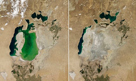
A large section of the Aral Sea has completely dried up for the first time in modern history, according to Nasa.
Images from the US space agency’s Terra satellite released last week show that the eastern basin of the Central Asian inland sea – which stretched across Kazakhstan and Uzbekistan and was once the fourth largest in the world – was totally parched in August. Images taken in 2000 show an extensive body of water covering the same area.
“This is the first time the eastern basin has completely dried in modern times,” Philip Micklin, a geographer emeritus from Western Michigan University told Nasa. “And it is likely the first time it has completely dried in 600 years, since Medieval desiccation associated with diversion of Amu Darya to the Caspian Sea.”
In the 1950s, two of the region’s major rivers – the Amu Darya and and the Syr Darya – were diverted by the Soviet government to provide irrigation for cotton production in Uzbekistan and Turkmenistan, starving the Aral. It has been diminishing ever since, with the sea level dropping 16 metres between 1960 and 1996, according to the World Bank. Water levels are believed to be down to less than 10 per cent of what they were five decades ago.
A lack of rain and snow on the Pamir Mountains has contributed to the particularly low water levels this summer, said Micklin.

The Nasa satellite began taking pictures of the Aral Sea in 2000. Back then, it had already separated into the northern portion in Kazakhstan and the southern portion in Uzbekistan. The southern area of the Aral also split into western and eastern areas.
Efforts have been made to try and improve conditions in the north Aral sea, which were hailed as a partial success. But water from the Amu Darya and south Aral is still used to maintain Uzbekistan’s crucial cotton industry. Though water levels do fluctuate, few believe they could ever return to those seen in the 1960s .
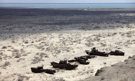
More than 60 million people live around the Aral Sea basin. The lack of water has devastated the region’s fishing industry, leaving ship graveyards as well as large areas of salted sand, which is easily kicked up by winds and contributes to health problems.


Comments (…)
Sign in or create your Guardian account to join the discussion